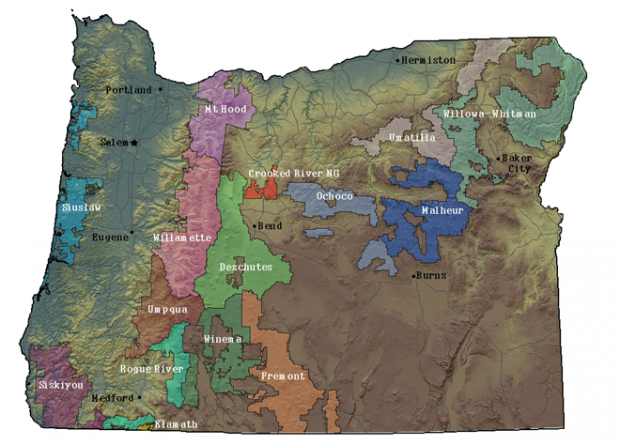
The list of call numbers below will help you navigate the Map & Aerial Photography Library. The actual maps can be found in the library's general section, the filing cabinets on the lower level (under the hanging sign "Science Maps") or in our historic collections. There may be a number of revisions or copies for any of the maps. You may also find USGS topographic maps to be of use when doing forest research.
Oregon National Forests Map

| Forest Name | Classification Number |
|---|---|
| Fremont | G 4292 F7 |
| Malheur | G 4292 M3 |
| Mt. Hood | G 4292 M6 |
| Rogue River | G 4292 R713 |
| Siskiyou | G 4292 S55 |
| Siuslaw | G 4292 S6 |
| Umatilla | G 4292 U5 |
| Umpqua | G 4292 U6 |
| Wallowa-Whitman | G 4292 W32 |
| Willamette | G 4292 W5/ |
| Winema | G 4292 W |
| Wilderness Area | Classification Number |
|---|---|
| Badger Creek | G 4292 .B3 |
| Black Canyon | G 4292 B57 |
| Boulder Creek | G 4292 .B7 |
| Bridge Creek | G 4292 B84 |
| Bull of the Woods | G 4292 B85 |
| Cummins Creek | G 4292 C8 |
| Diamond Peak | G 4292 D5 |
| Eagle Cap | G 4292 E15 |
| Gearhart Mountain | G 4292 G43 |
| Hells Canyon | G 4292 .H43 |
| Kalmiopsis | G 4292 .K35 |
| Mill Creek | G 4292 M527 |
| Mount Hood | G 4292 M615 |
| Mount Jefferson | G 4292 M62 |
| Mount Thielsen | G 4292 M64 |
| Mount Washington | G 4292 M64 |
| Mountain Lakes | G 4292 M67 |
| North Fork John Day | G 4292 N7 |
| North Fork Umatilla | G 4292 N72 |
| Red Butte | G 4292 R44 |
| Sky Lakes | G 4292 S618 |
| Strawberry Mountains | G 4292 S75 |
| Three Sisters | G 4292 T5 |
| Waldo Lake | G 4292 W25 |
Oregon BLM Districts Map
| District Name | Classification Number |
|---|---|
| Central Oregon Public Lands | G4291.G5 1994 .U5 |
| Coos Bay | G4294.C5E63 .U5 |
| Eugene | G4292.E8E63 .U5 |
| Lakeview | G4291.G5 .U5 |
| Lower Deschutes Public Lands, | G4292.D42G5 1986 .U5 |
| Medford | G4294.M4G5 .U5 |
| Roseburg | G42924.R8E63 .U5 |
| Salem | G4294.S3E63 .U5 |
| Upper and Lower John Day Public Lands | G4292.J67G5 1991 .U5 |
| Vale | G4293.M3E63 .U5 |
